On flat terrain 1-1/2 miles south of Houston's central business district, the Westmoreland Historic District encompasses all or part of 8 blocks of a 12-block residential subdivision platted as Westmoreland Addition in 1902. Developed as a "private place" type neighborhood by the South End Land Company, the district contains an eclectic mixture of Late Victorian and early 20th-century house types of both large and moderate size. Community cohesion was ensured by organizing the grided street plan to limit access from outside the district, focusing instead on a broad central thoroughfare, Westmoreland Avenue. Street trees characteristic of the turn of the 20th century in Houston--live oaks, magnolias, and ornamental date palms reinforce the sense of visual cohesiveness provided by raised front porches, which are a repeating feature of individual houses. Despite the intrusion of a freeway along the east side of the district and replacement of some original houses with post-World War II garden apartment complexes, the Westmoreland Historic District retains its historic integrity, with 66 properties classified as Contributing resources.
The Westmoreland Addition was originally platted as a 12-block, 44-acre subdivision almost square in its configuration. Four streets (Hawthorne, Emerson, Westmoreland and Marshall avenues) run east-west, and three (Garrott Street, Flora and Burlington avenues) north-south. Although configured as a right-angle, the neighborhood streets are not continuous with those of surrounding subdivisions. There is no exit to the north (Courtlandt Place Historic District) and only one at the northwest corner, although the south and east sides had several entrances. A loss of integrity of buildings in the southwestern portion of the original subdivision and razing of the east side of Burlington Avenue for freeway construction has caused these portions (approximately one firth of the original area) to be eliminated.
Contributing houses have a uniform setback. Exceptions are modern apartments and vacant lots. The prevailing southeast wind from the Gulf of Mexico encouraged home builders to orient houses advantageously in the sub-tropical climate. This is most evident in sleeping porches, consistently located on the south and east sides of houses.
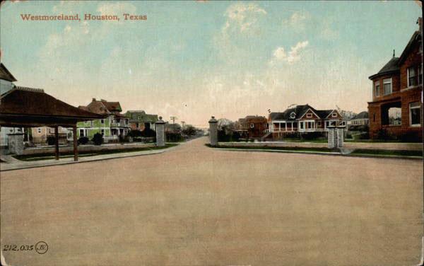
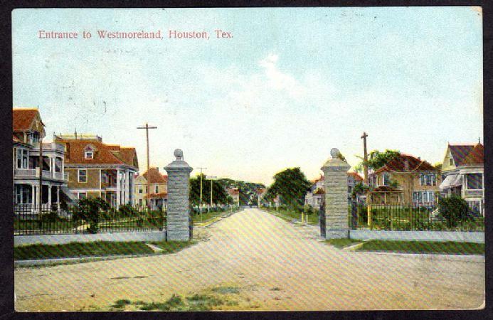
Historically, the principal entrance to the neighborhood was defined by cast stone gate piers at the east end of Westmoreland Avenue at its intersection with Louisiana Street and Berry Avenue. Streets were originally surfaced with crushed oyster shells, but have long since been covered in asphalt. Westmoreland Avenue is the broadest street in the neighborhood and it has the largest concentration of grand houses on large lots. Westmoreland is flat, like much of Houston. Streets are flanked by sidewalks and trees. Popular vegetation includes magnolia, mulberry, oak, elm, palm, yaupon and camphor trees, as well as crepe myrtles, waxleaf ligustrum, and junipers. Single family residences tend to have large, well kept yards, while the largely Noncontributing multiple family buildings stress parking. Open drainage ditches are found along Emerson and Flora avenues. High, solid board "privacy" fences are now found to the side and rear of many houses, and some properties have tall, open, iron fences in front.
The initial building campaign lasted through the decade following the platting of the neighborhood in 1902. Houses constructed at that time were 1-and 2-story single family dwellings usually of frame construction. Stylistically, Westmoreland houses reflected the popular styles of the day - late Victorian, Queen Anne, American Fout-Square, Craftsmen, and Colonial Revival variants were the most common. Full-length verandas supported by columns or brick piers, and sleeping porches were standard features, as were smaller, back service porches.
Most early Westmoreland houses were essentially square or rectangular in shape, although Queen Anne types tend to have more irregular footprints. Similarly, again excepting QueenAnne, roofs were typically hipped or gabled with broad overhangs. Most were clad originally in wooden shingles and gradually replaced with composition shingles.
Architectural styles changed following World War I in Houston and elsewhere, and the second and last major campaign of single family home construction in the Period of Significance. Houses were less likely to adhere to bungalow precedents and more often followed the variety of 20th century revival styles of the day. Such Colonial Revival, Mediterranean Revival, and Jacobethan Revival houses were two stories in height, but front porches were removed. Brick veneer or stucco replaced clapboard siding, and cast stone ornamentation appeared. Two of Westmoreland's earliest apartment houses, both in the Jacobethan Revival style and Contributing to the district, were constructed at that time.
A major characteristic of Westmoreland houses are glass front doors with transom and sidelights. There are many variants of that feature found - glass could be beveled or leaded (less commonly stained), and sometimes with a single sidelight. Windows frequently had a single-pane lower sash and complex, divided light upper sashes, particularly on the entrance fronts. Wooden siding, clapboard, and novelty siding such as washboard siding covered the body of houses, while ornamental shingles of varying shapes were found in gables.
Many houses had large entrance halls, frequently off center, containing a staircase with Colonial or Craftsman motif balustrades. Plans tended to be open, following front the entrance hall into the living room into the dining room. The now-moved Staiti House began on a more compartmentalized plan, but, with changing fashions, it was opened up before 1920 - other house may have been similarly modified. Kitchens, sometimes with butler's pantry, were enclosed downstairs, as were the typical two to four bedrooms and single bath upstairs.
Many early Westmoreland house had stables (garages after 1910) or garages with staff quarters above on the rear property line. These sometimes emulated the architecture, materials and detailing of the main house. Often they were much simplified.
The decades of the 1950s through the 1980s brought many changes to the neighborhood. Approximately 42 single family houses in the district were demolished and multi-family housing was built on 27 one to half-a-dozen of the original home sites. These were generally two stories in height, contemporary in design and sometimes disrespectful of the scale and vegetation of the neighborhood. Setbacks were adhered to, however. In the past decade, as the neighborhood rebounded, more sympathetic townhouse construction has occurred, taking into consideration the materials, massing and architectural vocabulary of Contributing member of the district and providing more sympathetic landscaping.
|